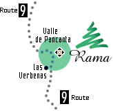
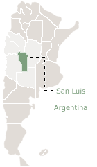
72km North of San Luis city, in the Valle de Pancanta, Sierras de San Luis central mountains, 1550 meters over sea level height, with direct access from Provincial Route N°9, "Estancias RAMA" (2.200 hectares) is located. This is where the Forestry Project takes place.
Geographic location coordinates:
32° 52.176' S
66° 06.293' W
3/4/2014 5:35:46 PM
Rama Forestry Project - Estancia Rama - Provincial Route 9 Km. 72 - Valle of Pancanta -
(5701) San Luis - Argentina / TE: +54 2652 447480 / +54 2652 452000 ext 4308
rama@rama.com.ar

 72km North of San Luis city, in the Valle de Pancanta, Sierras de San Luis central mountains, 1550 meters over sea level height, with direct access from Provincial Route N°9, "Estancias RAMA" (2.200 hectares) is located. This is where the Forestry Project takes place.